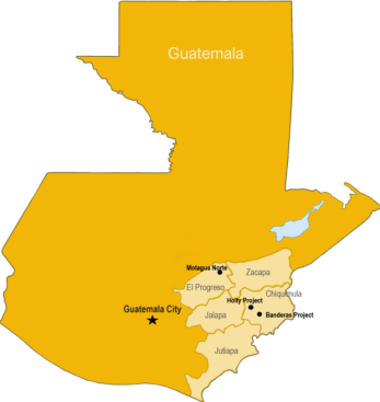
Holly Project
The Holly property straddles the regional Jocotan Fault which forms part of the 400 km long by up to 80 km wide deformation zone that separates the North American and Caribbean plates. At the Holly project, the Jocotan is mineralized and forms a distinct east-west trending ridge separating older metamorphosed sediments to the north and much younger volcanics to the south. The company geologists have discovered multiple high-grade gold and silver occurrences along and crosscutting this portion of the Jocotan and have had success in the limited drilling that has been done on these targets thus far. An initial resource has been defined at Holly on the La Pena vein, one of the northeast veins that cuts across the Jocotan Fault.
Holly Project Highlights
- Low sulphidation gold silver epithermal system
- Multiple high-grade quartz veins intersecting wide mineralized Jocotan fault zone
- Located in eastern Guatemala in a terrain with world class gold-silver mines and deposits
- Key features of both Pan American Silver’s Escobal Mine and Bluestone Resources feasiblity-stage Cerro Blanco deposit
- High-grade gold-silver mineralization
- Surface results to 396 g/t gold and 7092 g/t silver
- 2002 drill results to 6.00 m @ 43.56 g/t gold and 1,617 g/t silver
- Ongoing drilling producing results to 4.58 m @ 79.84 g/t gold, 5,053 g/t silver
- A maiden Inferred Mineral Resource has been estimated for the first target, La Peña vein.1
- The high grade La Peña vein remains open to expansion along strike and importantly at depth, where exceptionally high-grade results have been returned.
- Multiple other drill targets remain un-tested at Holly with potential for new discoveries.
- Joint Venture with Radius Gold Inc.
- Holly is 60km by paved road to Bluestone Resources planned processing plant.
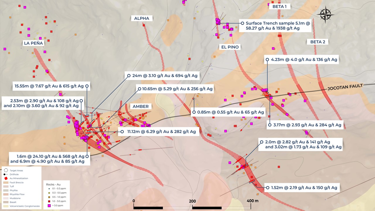
Holly Project Overview
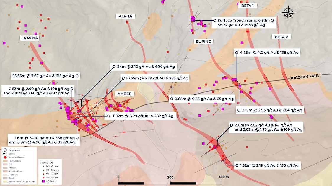
Holly Project; Drill summary with drill collars and traces.
La Peña Resource Model (June 2022)
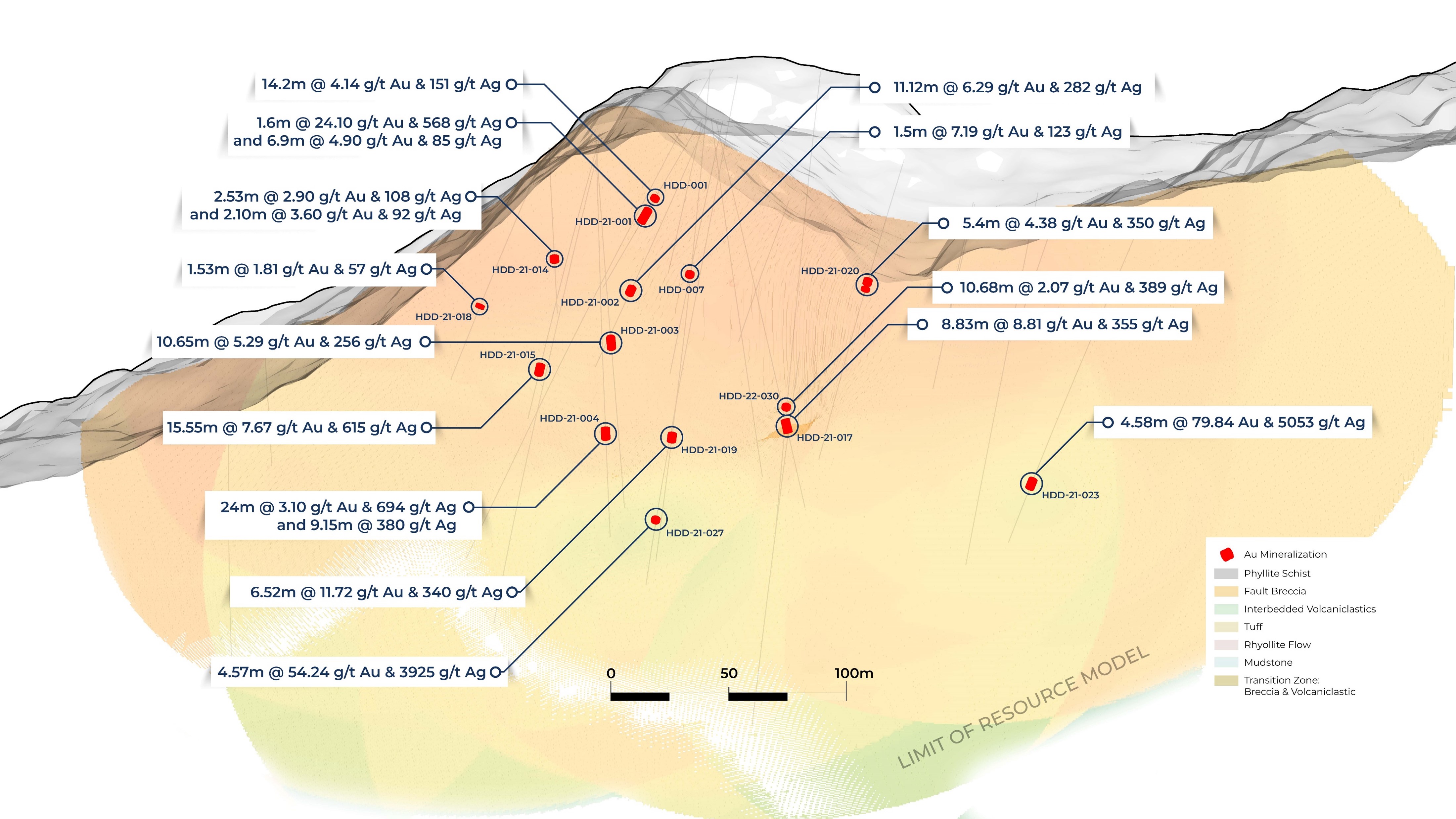
Table 1: Holly, Peña Vein Resource Estimate
(Effective date 7th June, 2022)
CATEGORY | CUT-OFF GRADE AUEQ² (G/T) | TONNES ABOVE CUTOFF (MILLIONS) | GOLD (G/T) | SILVER (G/T) | GOLD (OZ) | SILVER (OZ) | GOLD EQUIVALENT² (G/T) | GOLD EQUIVALENT² (OZ) |
|---|---|---|---|---|---|---|---|---|
INFERRED | 3.00 | 1.32 | 6.46 | 256 | 272,110 | 10,913,360 | 9.57 | 406,316 |
- Resources estimated using a 3.0 g/t Gold equivalent cut-off grade and a top cap grade of 100 g/t Gold and 2,000 g/t Silver and presented on a 100%-basis
- Gold Equivalent Au(eq) values based on Au US$1800 and Ag US$22 using formula (Au g/t + (Ag g/t*0.01222))
- Mineral Resources which are not Mineral Reserves have not demonstrated economic viability. The estimate of Mineral Resources may be materially affected by environmental, permitting, legal, marketing, or other relevant issues. The mineral resources in this report were estimated using the Canadian Institute of Mining, Metallurgy and Petroleum standards on mineral resources and reserves, definitions, and guidelines prepared by the CIM standing committee on reserve definitions and adopted by the CIM council. Notwithstanding, to meet the requirement that the reported Mineral Resources show “reasonable prospects for eventual economic extraction”.
- The quantity and grade of reported Inferred Resources in this estimation are uncertain in nature and there has been insufficient exploration to define these Inferred Resources as an Indicated or Measured Mineral Resource. It is uncertain if further exploration will result in upgrading them to an Indicated or Measured Mineral Resource category.
- Contained metal and tonnes figures in totals may differ due to rounding.
- The effective date of the Mineral Resource Estimate is June 7, 2022 and a Technical Report on the Holly property is filed on the Company’s website and SEDAR.
The Mineral Resource Estimate is underpinned by data from 21 diamond drillholes totaling 3,707m of drilling. Drill spacing ranges between 20 and 100m. All sample data was composited to a 2D dataset (linear grade and true thickness values) prior to analysis and estimation. The sample database and the topographic survey were reviewed and validated by Bruce Smith, Ludving Monroy and Shawn Rastad prior to being supplied to John Arthur, an independent UK based Resource Consultant. Such review and validation help to support the reliability of the estimate. Geological domain modelling was completed by Bruce Smith and Dr John Arthur. Mineral Resource domain modelling, grade interpolation, Mineral Resource classification and reporting of the Mineral Resource statement, was performed by Dr John Arthur. Dr Arthur, Mr. Smith, Mr. Monroy and Mr. Rastad are “qualified persons” within the meaning of National Instrument 43-101 Standards of Disclosure for Mineral Projects (“NI 43-101”). Block modelling was carried out using cell dimensions of 32mE by 32mN by 8 mRL and was coded to reflect the surface topography and mineralized zones. Density values were globally assigned into two zones, an upper zone between 50 to 100m from surface had an average density of 2.33t/m³ and below this an average density of 2.52t/m³ was applied. The Mineral Resource Estimate has been classified based on data density, data quality, confidence in the geological interpretation and confidence in the robustness of the grade interpolation. The effective date of the Mineral Resource Estimate is June 7, 2022 and a Technical Report on the Holly property is filed on the Company’s website and SEDAR.
Section Maps

La Peña Vein, Long Section
La Peña Vein, Cross Section
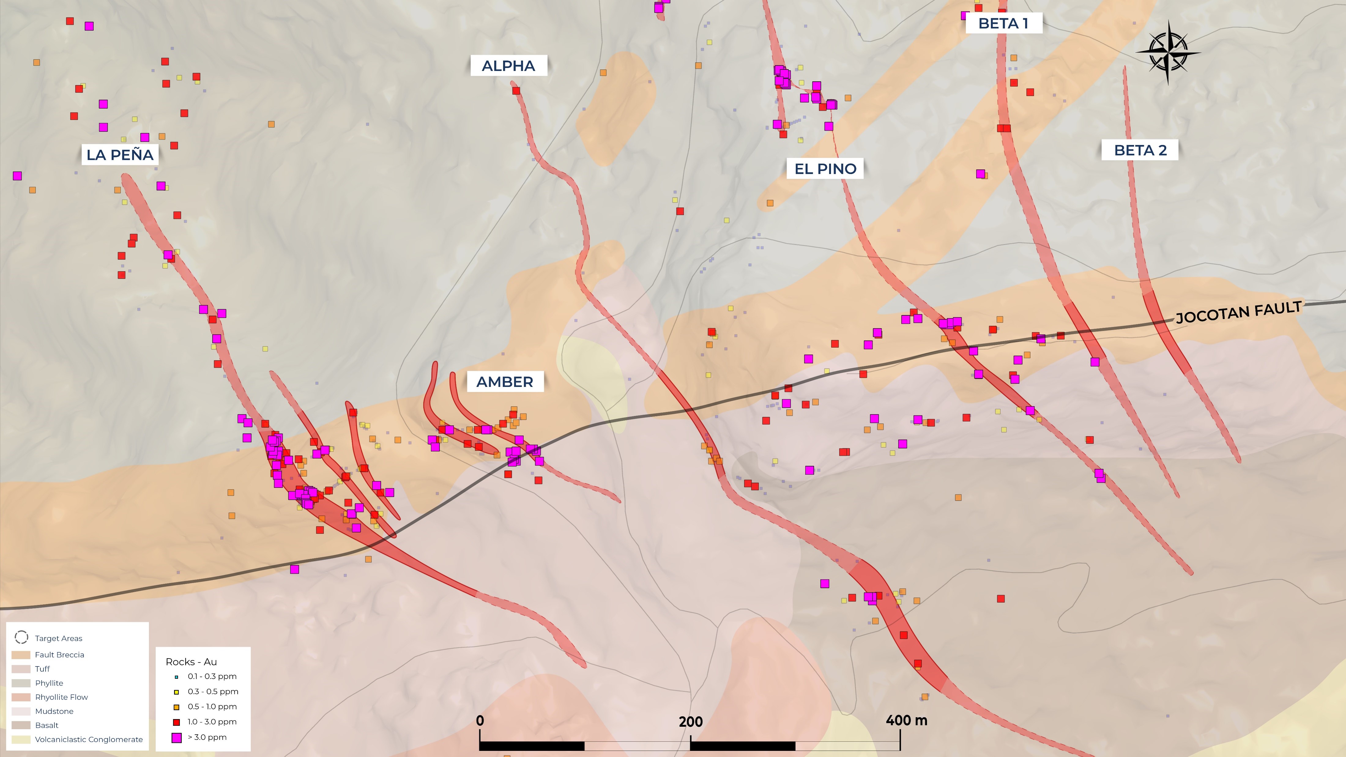
Holly Property Plan and Geochemistry
Holly Project Geological Map with Au Geochemistry.
Project History
- Discovery of Holly deposit by a Gold Group Management Inc. company
- Initial discoveries by Radius Gold Inc. geologists in 2002/3
- Bluestone Resources neighbouring Cerro Blanco deposit also discovered by a Gold Group Management company
- Several shallow drill programs were conducted over 36 months
- Extensive high-grade drill intercepts indicated potential. Weak gold market halted exploration
- No drilling on property package since 2006
- In 2007, Goldcorp makes the Escobal world class silver discovery 20 km’s away
- Multiple targets open for expansion or are untested by drilling
DATA VERIFICATION
All data presented in this webpage were considered historic by Bruce Smith, MAIG, who was the Qualified Person under NI43-101 guidelines for Volcanic Gold Mines Inc until December 2022. Luc English, CGeol is Volcanic Gold’s current Qualified Person. Bruce Smith remains as a Technical Advisor to Volcanic Gold Mines. Datasets in company archives were verified by Mr. Smith to ensure that drill intercepts or surface showings reported corresponded with data in the company databases. The integrity of the databases was verified for completeness and errors. The databases were periodically spot-checked against original paper assay certificates to verify accuracy. Mr. Smith, found no serious errors in the databases during that period.
A site visit was completed by Bruce Smith MAIG QP between and 12th and 16th of March 2019. Mr. Smith visited the main outcrops, trenches and drill pads at both the Holly and Banderas projects. All descriptions in the above Summary match geologically with the field occurrences. Historic drill collars in most locations were found to be well marked and still cemented in place and the coordinates matched the coordinates given in the data bases.
The geochemical analysis presented in this website for both surface sampling and drilling are deemed by the Mr. Smith to be reliable given the historic nature. Mr. Smith has worked with the key personnel responsible for the majority of drilling, sampling and geological work at Holly and Banderas at many other projects over 20 years and can vouch that they are trained and capable of working in line with international best current practice in mineral exploration. Samples were analysed at certified laboratories. Mr. Smith checked for routinely inserted multi-element geochemical standards, duplicates and blanks into the sample database monitoring laboratories performance. Quality control samples submitted were returned within acceptable limits.
DRILLING AND SAMPLING
The locations of the majority of historic drill collars were resurveyed in 2011. All historic drill core is stored in Guatemala at a secure facility where Mr. Smith has examined the majority of the major mineralized intercepts and validated these against historic drill logs (when available) and assays.
In some cases, data on QA/QC programs is incomplete or no longer exist within the datasets or in the company archives and could not be verified. It is clear, however, that QA/QC procedures have been in place on the Project since its beginnings. In such cases Mr. Smith has verified with past project QPs that effective QA/QC procedures were practiced, including the regular insertion of reference materials, blanks, and field duplicates. Furthermore, continuity has been maintained with Radius Gold Inc. Guatemalan staff since the Project’s inception, ensuring consistency of drilling, sampling, and logging procedures on site.
Mr. Smith was satisfied that sampling and drilling undertaken by Radius Gold’s local staff, Project optionees, and under the supervision of various QPs have been performed to industry-accepted professional standards and considers the data presented in the above Summary to be reliable.
References:
- See News Release “Volcanic Gold Mines Announces Initial Resource estimate of 406,316 oz at 9.57 g/t Gold Equivalent at Holly,” June 9, 2022.